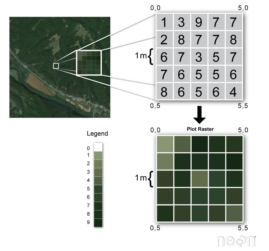
Raster Data Model
Raster Data Model
Represents space continuously:
- Rectangular grid of equally sized cells
- Each cell only has one value
Raster Data Model
Multiple attributes, require multiple bands
- Standard color photos have three bands:
- Red, green, & blue
- LANDSAT8 has 11 bands:
- "False Color Images"
- Spectral Indices (NDVI)
Resolution vs. Extent
Resolution: (aka cell size) is the smallest resolvable feature.
- 1 m x 1 m = 1 m2
Extent: (aka domain) depends on number of rows and columns along with the cell size.
- 5 rows x 5 columns = 25 cells
- 1 m cell size
- Covers 5 m x 5 m = 25 m2
Resolution vs. Extent
Resolution: 10 m cell size = 100 m2 area per cell.
Extent: varies with number of cells and cell size.
| Rows | Columns | Extent |
|---|---|---|
| 5 | 5 | 50 m x 50 m = 2,500 m2 |
| 5 | 10 | 50 m x 100 m = 5,000 m2 |
| 100 | 100 | 1,000 m x 1,000 m = 1,000,000 m2 |
TopHat Question 1
Raster resolution is dictated by the number of rows and columns, raster extent is dictated by the cell size.
- True
- False
- Sometimes True, Sometimes False
Mixed Pixel Problem
One cell: one value
- What if it covers multiple values?
- A: Winner take all
- B: Cell center
- Other options?
- Containment - if a value of interest is anywhere within a cell
- e.g. invasive species presence
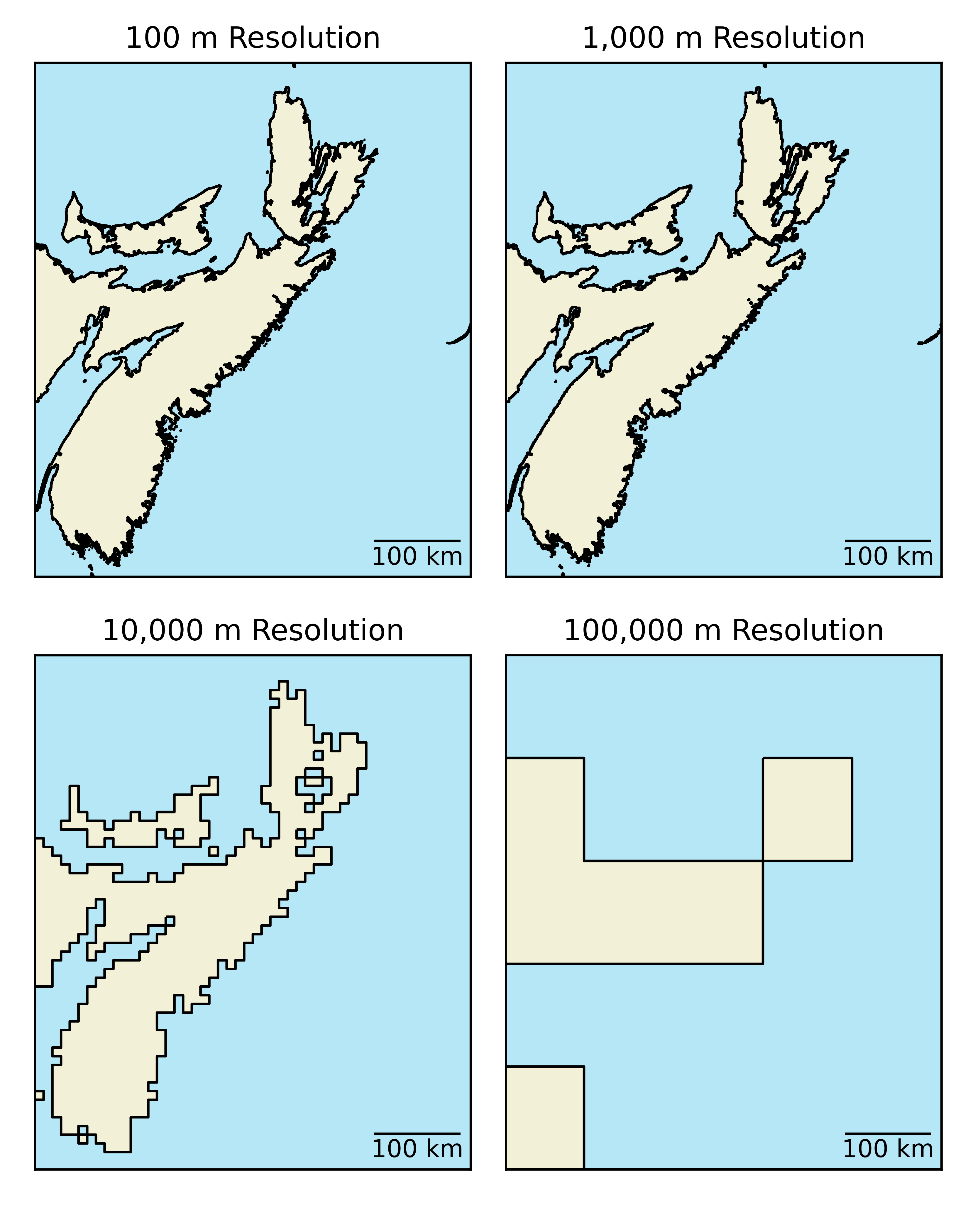
Implications
Loss of information during rasterization.
- A "bigger" issue for larger cells.
- At a certain point features become unrecognizable.
- Higher resolution = larger file for equivalent areas.
TopHat Question 2
This term describes how information is lost when creating a raster image.
- Resolution
- Domain
- Mixed pixel problem
- Rasterization
File Size
The number of cells per image dictates file size.
- Cells = rows x columns x bands
- Increases exponentially with resolution
- For a given extent
- Increases linearly with number of bands
| Extent | Bands | Cell Size | Number of Cells |
|---|---|---|---|
| 1x1km | 1 | 100m | 100 |
| 1x1km | 1 | 1m | 1,000,000 | 1x1km | 3 | 100m | 300 |
| 1x1km | 3 | 1m | 3,000,000 |
Why does this matter?
Downloading, uploading, and processing times will all increase as the file size increases.
- Large raster datasets are computationally "expensive"
- More cells = more "overhead"
- Practically speaking, how will this impact you?
TopHat Question 3
You downloaded a 3 band LANDSAT8 image covering the UBC campus. The image's dimensions are 6000m (rows) by 4500m (columns) and the resolution (cell size) is 30m. How many cells does the image contain?
- 30,000
- 90,000
- 900,000
- 2,700,000
- 27,000,000
- 81,000,000
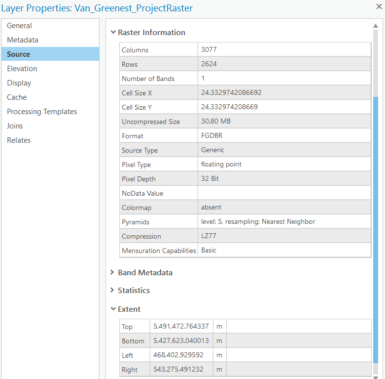
Metadata in ArcPro
Raster Overlay
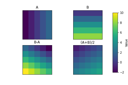
Raster data can be used to evaluate algebraic expressions easily and efficiently.
- A: Winter Temperature
- B: Summer Temperature
- Range: B-A
- Average: (A+B)/2
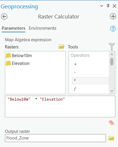
Raster Calculator
The tool for this in Arc is called the "Raster Calculator"
- Raster layers can be "variables" in linear equations
- Perform simple calculations incorporating one or multiple layers
- Ideally, layers should have the same resolution and extent
- Resampling is required if not
- Output will be restricted to "smallest" extent
Key Advantages
The raster data model is well suited for continuous phenomena:
- Continuous in space
- Complete coverage within the domain (extent), everywhere has a value
- Continuous in space and time
- Bands can be used to represent time steps
- Common tool approach for climate data
- i.e., bands 1, 2, 3 ... could represent mean Jan, Feb, Mar temperatures
- Simple data structure makes raster overlay easy and efficient
- Multiple raster layers can be combined and evaluated using expressions
- Easy to "show" others what has been done
GeoTIFF
One of the most common/functional raster formats, based of the Tag Image File Format (TIFF). A TIFF file stores metadata (data about the data) as tags. A GeoTIFF is a standard .tif image format plus additional tags spatial tags denoting spatial information including:
- Extent (minimum x,y and maximum x,y)
- Resolution (cell size)
- Projection, Coordinate system, and datum
Other file types
Raster data can come in many different formats. You will likely encounter when working with raster data include:
- IMG - A proprietary image format commonly used by ESRI products
- JPEG2000 - A geospatial version of the common .jpg image type
- ASCII - An older human readable format (simple text file) with slower performance than the types listed above
TopHat Question 4
The Raster Calculator tool lets you:
- Evaluate algebraic expressions using raster layers as inputs
- Create raster layers
- Calculate the area of raster layers
- Overlay raster and vector layers