Vector Analysis Methods
Vector Analysis Methods
Many operations can be done with vector data.
- Some methods are very similar.
- Distinctions between methods can be subtle, but important.
- Can complete the same tasks, but need slight changes to a workflow.
- Typically in GIS there are multiple ways to get the same answers.
- Some "routes" are just more direct.
Querying Attributes
Finding features of interest based on attributes.
- A good way to reduce data volumes, export queries to new layers
- In ArcGIS Pro you can Select by Attribute
- Uses SQL (Structured Query Language)
- Check equality, relative magnitude, etc.
- Combined with operators: AND / OR
- If we're only interested in historic residential buildings:
- Where "YEAR BUILT" ≤ 1950 AND "TYPE" = "Residential"
- Save as a new layer, won't have to search through all the objects every time.
Select by Attribute
Sample SQL queries
- Where "SPECIES" = "Pine"
- Where "SPECIES" ≠ "Pine"
- Where "HEIGHT" ≤ 5
- Where "SPECIES" = "Pine" AND "HEIGHT" ≤ 5
- Where "SPECIES" = "Pine" fc0314OR "HEIGHT" ≤ 5
| Species | Age | Height |
| Pine | 10 | 5 |
| Pine | 95 | 28 |
| Oak | 200 | 25 |
| Oak | 5 | 4 |
Select by Attribute
Sample SQL queries
- Where "SPECIES" = "Pine"
- Where "SPECIES" ≠ "Pine"
- Where "HEIGHT" ≤ 5
- Where "SPECIES" = "Pine" AND "HEIGHT" ≤ 5
- Where "SPECIES" = "Pine" OR "HEIGHT" ≤ 5
| Species | Age | Height |
| Pine | 10 | 5 |
| Pine | 95 | 28 |
| Oak | 200 | 25 |
| Oak | 5 | 4 |
Select by Attribute
Sample SQL queries
- Where "SPECIES" = "Pine"
- Where "SPECIES" ≠ "Pine"
- Where "HEIGHT" ≤ 5
- Where "SPECIES" = "Pine" AND "HEIGHT" ≤ 5
- Where "SPECIES" = "Pine" OR "HEIGHT" ≤ 5
| Species | Age | Height |
| Pine | 10 | 5 |
| Pine | 95 | 28 |
| Oak | 200 | 25 |
| Oak | 5 | 4 |
Select by Attribute
Sample SQL queries
- Where "SPECIES" = "Pine"
- Where "SPECIES" ≠ "Pine"
- Where "HEIGHT" ≤ 5
- Where "SPECIES" = "Pine" AND "HEIGHT" ≤ 5
- Where "SPECIES" = "Pine" OR "HEIGHT" ≤ 5
| Species | Age | Height |
| Pine | 10 | 5 |
| Pine | 95 | 28 |
| Oak | 200 | 25 |
| Oak | 5 | 4 |
Select by Attribute
Sample SQL queries
- Where "SPECIES" = "Pine"
- Where "SPECIES" ≠ "Pine"
- Where "HEIGHT" ≤ 5
- Where "SPECIES" = "Pine" AND "HEIGHT" ≤ 5
- Where "SPECIES" = "Pine" OR "HEIGHT" ≤ 5
| Species | Age | Height |
| Pine | 10 | 5 |
| Pine | 95 | 28 |
| Oak | 200 | 25 |
| Oak | 5 | 4 |
TopHat Question 1
How many rows in this table would the following query return?
Where "SPECIES" = "Pine" AND "SPECIES" = "Oak"
| Species | Age | Height |
| Pine | 10 | 5 |
| Pine | 95 | 28 |
| Oak | 200 | 25 |
| Oak | 5 | 4 |
| Birch | 5 | 4 |
TopHat Question 2
How many rows in this table would the following query return?
Where "SPECIES" = "Pine" OR "SPECIES" = "Oak"
| Species | Age | Height |
| Pine | 10 | 5 |
| Pine | 95 | 28 |
| Oak | 200 | 25 |
| Oak | 5 | 4 |
| Birch | 5 | 4 |
Proximity Analysis
Looking at spatial relationships within or between layers.
- A good way to reduce data volumes, export queries to new layers.
- Multiple options, depending on our needs.
- If we're only interested in buildings within 1 km of streams:
- Identify by proximity
- Save as a new layer, won't have to search through all the objects every time.
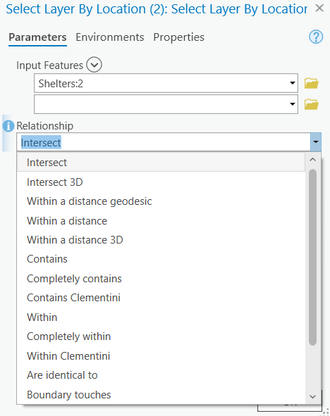
Select by Location
Use Select by Location when you want to check for spatial relationships. There are many relationships we can check for:
- Containment
- Intersection
- Distance
Geometric Manipulations
These methods create new layers with altered "geometries". Geometry is a term we use to refer to points, lines, and/or polygons in a vector layer.
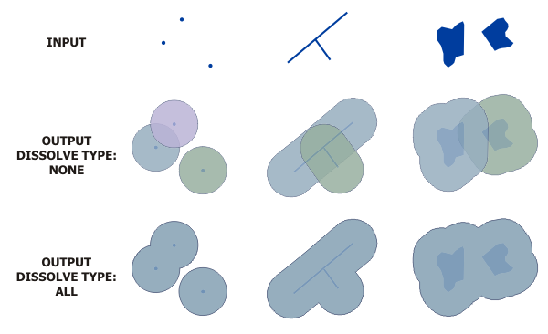
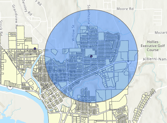
Buffering
Use the Buffer tool to create a new Polygon layer based on distance.
- Buffer points, lines, or polygons using a buffer distance or set a field to specify varriable distance.
- Use the Multiple Ring Buffer tool for multi-criteria buffers.
Example From ESRI Docs
Buffering
Use the Buffer tool to create a new Polygon layer based on distance.
- Buffer points, lines, or polygons using a buffer distance or set a field to specify varriable distance.
- Use the Multiple Ring Buffer tool for multi-criteria buffers.
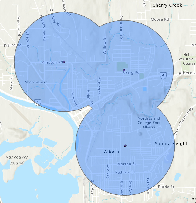
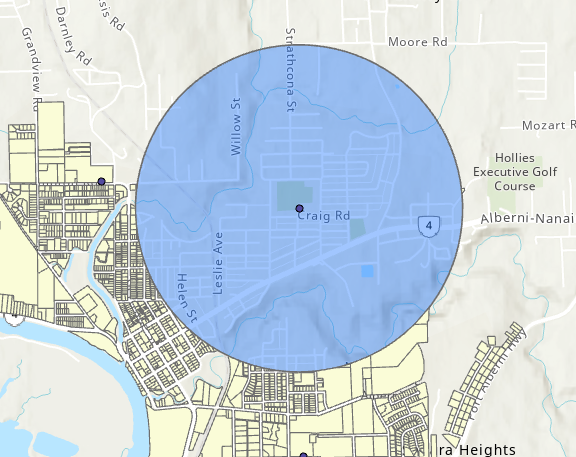
Buffering Tsunami Shelters

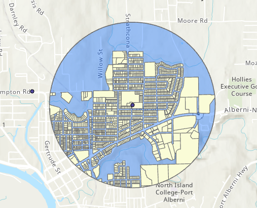
Dissolve
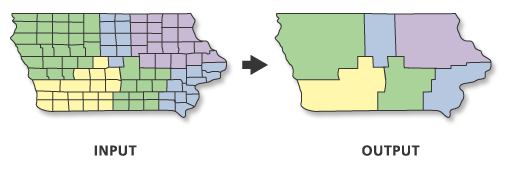
Dissolve aggregates features.
- Merges objects completely or by attribute(s).
- Can calculate statistics for aggregated regions.
- Useful if our data is more "complex" than we need it to be.
Example From ESRI Docs
Dissolve
Dissolve aggregates features.
- Merges objects completely or by attribute(s).
- Can calculate statistics for aggregated regions.
- Useful if our data is more "complex" than we need it to be.
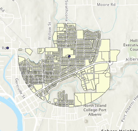
Dissolve Tsunami Shelter Buffers
TopHat Question 3
This tool allows us to aggregate vector objects in a layer, either completely or by specific attribute values.
- Buffer
- Dissolve
- Select by Attribute
- Merge
Feature Overlay
When we have multiple data layers and we want to combine them to form a new output.
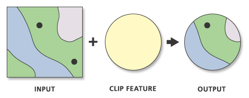
Clip
Use the Clip tool to cut one layer down to the boundaries of another.
- Works like a cookie cutter
- Useful when we want to focus on a study area
- Does not alter attributes
- Input layer: our data layer
- Clip layer: the study area
Example From ESRI Docs
Input
Output
Erase
Use the erase tool to remove the area of one layer from another.
- Opposite of the clip tool
- Does not alter attributes
- Useful when we want to discard/exclude an area
Example From ESRI Docs
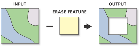
Input
Output
Intersect
Intersect lets us see only where layers overlap and combine overlapping attributes.
- Can handle more than two layers at once
- Splits features by overlaps and merges attribute tables
- Useful when we want to merge and parse data at the same time
Example From ESRI Docs
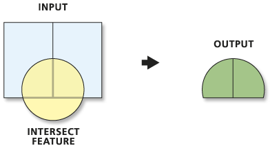
Input
Output
Union
Use the Union tool to combine multiple layers, split features where they overlap and combine attributes.
- Similar to intersect, but keeps overlapping areas
- Adds attributes from all overlaps.
- Can handle more than two layers at once.
- Null values where for new attributes where no overlaps are present.
- Useful when we want to merge layers.
Union
Use the Union tool to combine multiple layers, split features where they overlap and combine attributes.
- Similar to intersect, but keeps overlapping areas

Many More
There are many more vector overlay tools! I have presented some of the the most frequently used tools, but if you have specific use cases you may need others. I can't cover them all, and I don't want to overwhelm folks.
TopHat Question 4
Clip and erase remove portions of layer based on location relative to another layer but they do not alter the attribute table.
- True
- False