Framing the Problem
Table of contents
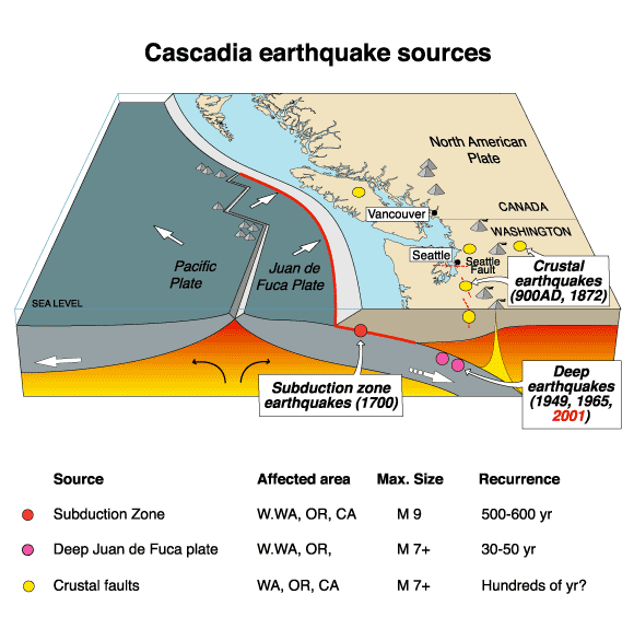
The Cascadia Subduction Zone
Just off of the West Coast of Vancouver Island, is the Cascadia Subduction Zone (CSZ). Until recently, the common scientific theory was that the CSZ was incapable of producing megathrust earthquakes and their associated Tsunami’s because “no sizable earthquake has occurred on it since European settlement began” (Ludwin et al. 2005).
Traditional Knowledge and Records of Past Tsunamis
Despite the scientific communities’ assumptions that the CSZ was not a threat, knowledge of the destructive potential of the CSZ was preserved in the oral histories of coastal indigenous peoples from British Columbia to Northern California. There are numerous histories describing a massive earthquake and tsunami that occurred sometime around 1700. These histories were transcribed between 1860 and 1964. Read the highlighted sections of Ludwin et al. (2005), which can be found here
It wasn’t until the 1990’s that scientific research began to shown that the CSZ was capable of producing megathrust earthquakes and tsunamis. Tree ring studies and historical accounts of a Tsunami in Japan pinpoint the timing of the last major CSZ earthquake at 21:00 Pacific time on January 26, 1700. In fact, there have been at least seven megathrust earthquakes exceeding 8.0 magnitude in the last 3500 years. The recurrence interval for massive earthquakes along this fault line are estimated to be between 243 and 500 years. In 2010, geologists predicted a 37% chance of a magnitude 8.2+ event within 50 years, and a 10 to 15% chance that the entire Cascadia subduction zone will rupture with a magnitude 9+ event within the same time frame.
This example highlights both the arrogance of the scientific community and the lack of value it has historically attributed to traditional knowledge.
Unique Geography
On March 28th, 1964 a megathrust earthquake (9.2 magnitude on the Richter scale) occurred in southern Alaska. Known as the “Good Friday” earthquake, it was responsible for 131 deaths: 9 from the earthquake itself, and 122 from the subsequent Tsunami, reaching as far away as Crescent City, California. In British Columbia, the Tsunami’s impacts were most devastating in Port Alberni, where 55 homes were washed away and 375 more were damaged. Port Alberni is especially vulnerable to Tsunamis because of its specific geography. Located at the head of 40km long fjord, Tsunami waves are amplified as they are funneled up the fjord. Read the highlighted portions of the introduction section in Fine et al (2008) which can be found here . You can also watch the simulation shown below for a visualization of what is going on.
Simulated Wave Heights
Defining the Project Area
In light of this research, the city of Port Alberni submitted an application for funding to update their Tsunami warning and response infrastructure. The city was recently granted funding and has hired you as a GIS consultant to assess the potential impacts of an 8.5 magnitude earthquake occurring directly off the west coast of Vancouver Island that would produce an estimated wave height of 10 meters.
Research Question
How would a catastrophic tsunami potentially impact Port Alberni? The city wants to know:
1 Which roads are at risk of flooding or damage?
2 Which properties in the city are at risk?
3 How many people in Port Alberni are potentially living in areas at risk?
4 Are the Tsunami Shelters sufficient?
Workflow
1 Identify at risk areas based on elevation and distance from coast.
2 Overlay vector layers to highlight features at risk.
3 Visualize and analyze the results.
References
Fine, I. V., Cherniawsky, J. Y., Rabinovich, A. B., & Stephenson, F. (2008). Numerical Modeling and Observations of Tsunami Waves in Alberni Inlet and Barkley Sound, British Columbia. Pure and Applied Geophysics, 165(11–12), 2019–2044. https://doi.org/10.1007/s00024-008-0414-9
Ludwin, R. S., Dennis, C., McMillan, L., & Clague, J. (2005). Dating the 1700 Cascadia Earthquake: Great Coastal Earthquakes in. Seismological Research Letters, 76(2), 141.