Coordinate Reference Systems
Please note: The Lab Questions corresponds to this lab assignment. There are questions you need to answer in the quiz that pertain to the lab, so its a good idea to skim the quiz questions before starting the lab.
This page contains instructions for the lab assignment, follow them to work through the lab in ArcGIS Pro. There are links to documentation where applicable along with embedded screenshots and videos in the instructions at some steps for reference. Feel free to work with peers in your lab section and don’t hesitate to ask your TA for help!
Warning: The ArcGIS Pro software package is updated frequently. The exact name/position of tools may diverge slightly from what you see in the screenshots or videos. Don’t worry recreating what you see in the videos exactly - just use them as a guide to help you work through things.
Overview
This lab will help you understand coordinate systems and map projections. It is also broken into two parts.
First you will work through a tutorial on map projections to learn how to work with projections in ArcGIS Pro
- Complete the four exercises and answer a series of questions relating to content in each exercise.
Then Make a visual comparison of four different coordinate systems that can be used to represent the Canada.
- Submit a map and answer an essay question.
Warning
If you are working on a geography lab computer Make Sure you are familiar with the procedures for saving your labs!
Part 1: Map Projections Tutorial
This map projection tutorial was created by Maya Daurio at the UBC Research Commons. The tutorial has four exercises. Download the data on the exercise page then work through each exercise to get a quick overview of how to work with coordinate systems in ArcGIS Pro.
Exercise 1 What Coordinate System is my Data in?
- Learn how to determine the coordinate system of a layer
Exercise 2 Projecting On-the-Fly
- Learn how ArcGIS Pro handles layers with different coordinate systems
Exercise 3 Project Your Data
- Change the coordinate system of your layer
Exercise 4 Calculating Population Density
- See the material impact of different projections
- Learn how to use Feature Datasets to manage projections
- Create a field and calculate population density
Part 2: Comparing Coordinate Systems
Four Ways to Display Canada
Create a figure showing Canada displayed using four different coordinate systems. Your submission should look something like the figure below, you can reference the video for help setting things up.
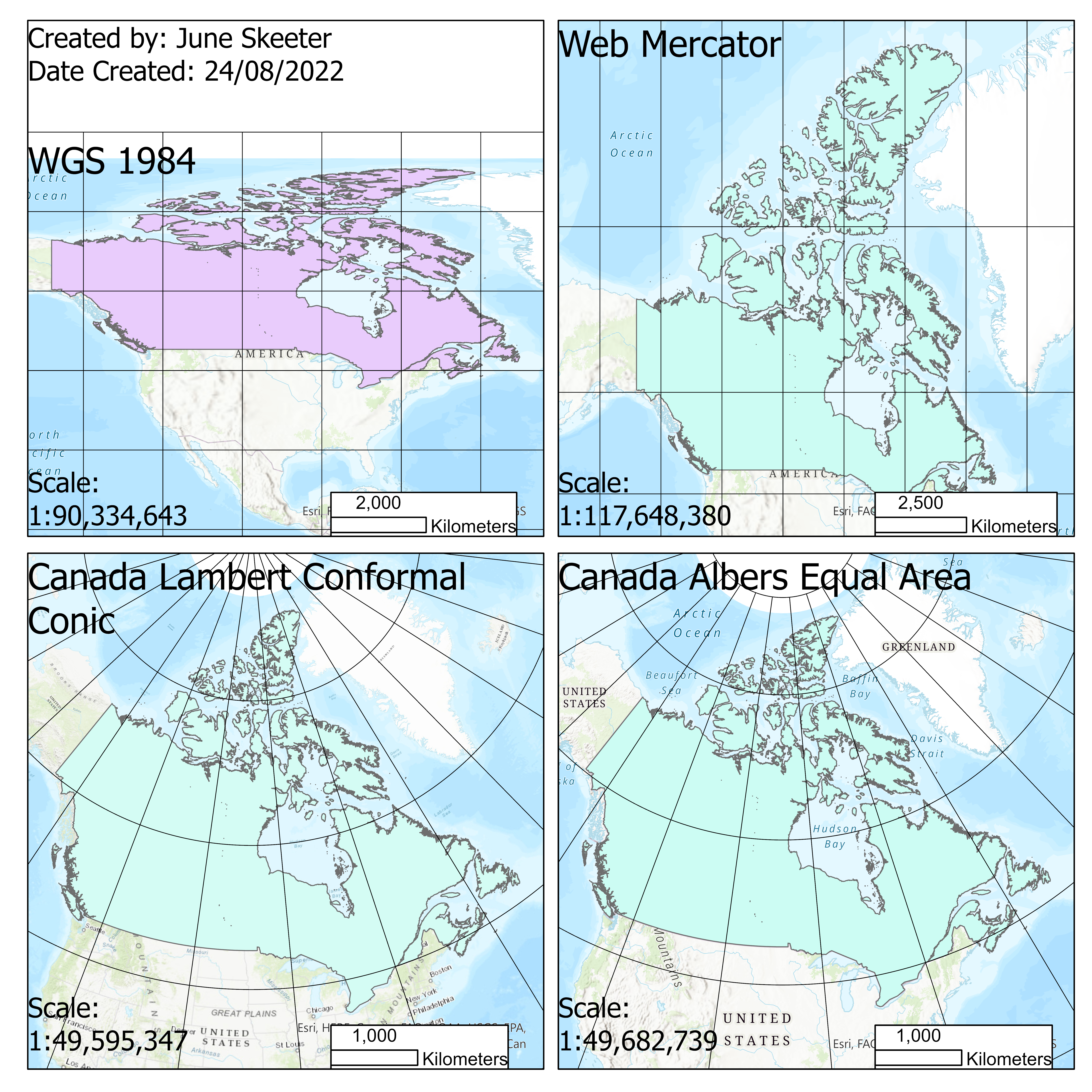
The key components you need for full credit are:
- Four maps on one sheet showing Canada displayed using the following coordinate systems:
- WGS 1984
- Web Mercator
- Canada Lambert Conformal Conic
- Canada Albers Equal Area
- Your name & date created
- Map scale shown in two ways on each map
- Scale text
- Scale bar
- A graticule showing lines of Latitude and Longitude
- Use the same spacing (15 degrees) for each map