ArcGIS Pro Tutorial
To get familiar with ArcGIS Pro, you will complete an Introduction to ArcGIS Pro tutorial and watch a four other short videos. The tutorial will take about 25 minutes and give you a brief overview of the ArcGIS Pro. The videos illustrate other important aspects of the ArcGIS Pro software package and will take about 10-15 minutes to watch.
Note This section covers questions 2 - 6 in the module quiz
Table of contents
Introductory Tutorial
If you have purchased ArcGIS Pro, you can sign in through the UBC ArcGIS online account you created. If you are using the lab computers, and don’t already have one, create a public account:
- Click “Sign In” in the top right of this page
- Click “Create a public account” and follow the steps
Go to the Introducing ArcGISPro tutorial. Watch the short introductory video, then work through the steps. You will be submitting a map from this tutorial for credit.
- You already have a project open, so you can start with Open the project step 2 Note.
- Note, if you have trouble in “Opening the project, Step 3” for either tutorial, you can download the data for off line use instead
- When you get to “Explore Views, Step 7”, double click on the map title and add your name following the video below.
File Submission
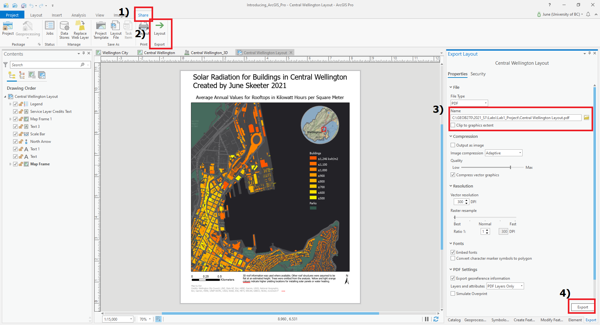
Save the layout as a .pdf, name it Central_Wellington_Layout.pdf. You will upload this map to canvas. To save your layout reference the image below.
1) Click Share.
2) Click Layout Export.
3) Specify the output location and name your file. Its best to use your Lab1_Project workspace so you can easily find this when its time to submit you map.
4) Click Export.
More Tutorial Videos
ESRI offers quite a few tutorials on ArcGIS Pro. Feel free to work though them if you have time! But we’re just going to watch the overview videos from four tutorials to learn a bit more about what we can do with ArcGIS Pro. I’ve hyperlinked to each tutoral page for your reference and embeded the relevant video below each video link.
Explore your data
This tutorial shows you how you can interact with and explore data layers. You can find the tutorial instructions here or watch the video below.
Make a layout
This tutorial shows you how you can use map layouts to visualize data. You can find the tutorial instructions here or watch the video below.
Use Geoprocessing Tools
This tutorial shows a few of the ways you can analyze geospatial data and see how different layers interact. You can find the tutorial instructions here or watch the video below.
Create Points on a Map
This tutorial shows how you can create a feature class and populate it with point features. You can find the tutorial instructions here or watch the video below.